
India’s Next Chicken Neck: India’s strategic “Chicken Neck” corridor is all set for a major connectivity boost to North-eastern states. In a major upgradation boost, Indian Railways has announced plans to construct a new underground railway line through the Siliguri Corridor, Known as “Chicken’s Neck”
Union minister for railways, information & broadcasting and electronics & information technology, Ashwini Vaishnaw mentioned that the project is designed to ensure secure, reliable and uninterrupted rail connectivity in this strategically “sensitive region”.
Why it’s termed as “Chicken Neck”
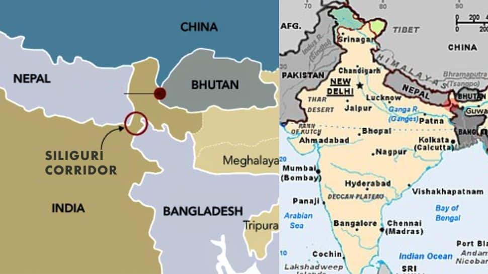
The route passes through the Siliguri Corridor, popularly known as the “Chicken Neck,” because of its shape on the map. The narrow strip of land resembles a chicken’s neck that connects the “body” (mainland India) to the “head” (the Northeastern states).
Geographically, this corridor is barely about 20–22 km wide at its narrowest point. It is bordered by Nepal on one side and Bangladesh on the other, with Bhutan and China located further north. Because it is such a thin land link, it forms the only direct surface connection between the Northeast and the rest of India.
Due to this narrow width and its sensitive international borders, the region holds immense strategic, military and logistical importance. Any disruption in this corridor can affect connectivity to all eight Northeastern states which is why infrastructure projects here, including the proposed underground railway line, are seen as highly significant.
Route Details
As per the deatils, the proposed rail route will come under the jurisdiction of the Katihar Division of the Northeast Frontier Railway. The line will start from Tinmile Hat, will pass through Rangapani, and will stretch onward to Bagdogra.
This new alignment will cover parts of:
Darjeeling district (West Bengal)
Uttar Dinajpur district (West Bengal)
Kishanganj district (Bihar)
The project includes an underground corridor stretching 35.76 km between Dumdangi and Bagdogra, of which 33.40 km lies between Dumdangi and Rangapani.
The alignment passes through the Siliguri Corridor – a narrow strip of land about 22 km wide that links the Northeast with the rest of India – a region widely regarded as one of the country’s most strategically significant and sensitive zones.
Underground rail line aimed to strengthen border security
This new underground route is expected to play a critical role due to it’s proximity to international borders with Nepal, Bhutan and Bangladesh and it’s vulnerability to natural disaster, congestion and security risks.
The alignment is certain to offer a protected and non-visible route, enabling the uninterrupted movement of defence personnel, military equipment and emergency relief supplies during emergencies.
High-Tech Construction & Design
The project will incorporate state of the art railway systems and engineering solutions, including:
A 2×25 kV AC electrification setup for efficient power supply
Automatic signalling (Standard-IV) to enhance safety and traffic management
VoIP-based communication systems supported by OFC and quad cables
Bridges designed as per RDSO standards for 25-ton axle loads
Twin underground tunnels constructed using the Tunnel Boring Machine (TBM) technique
NATM-built tunnels to facilitate crossovers
The use of these modern technologies is aimed at ensuring durability, safety and seamless rail operations in the strategically sensitive corridor.
Disclaimer : This story is auto aggregated by a computer programme and has not been created or edited by DOWNTHENEWS. Publisher: ZEE News


