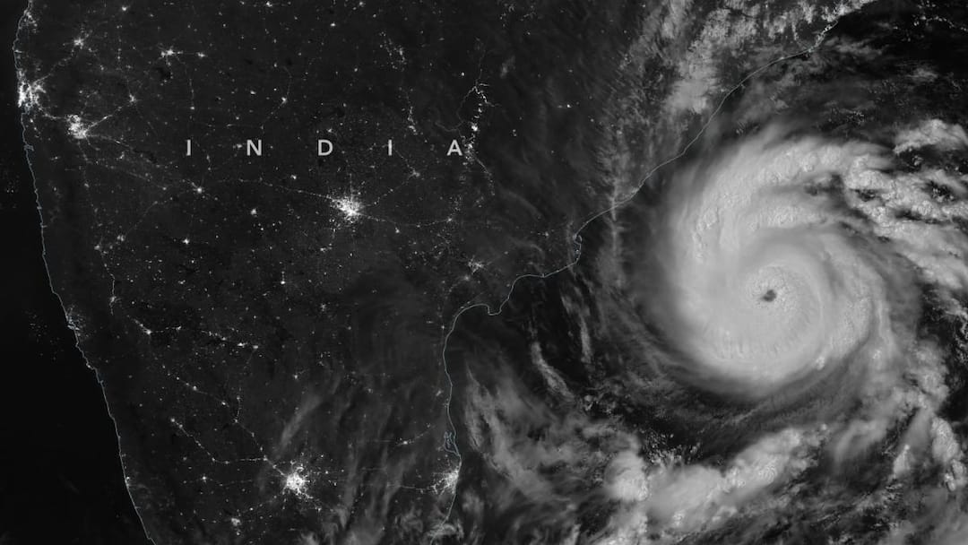
- Severe Cyclone Murasu to cross Andhra coast November 2/3.
- Landfall near Ongole, sustained winds 100-110 kmph.
- Tamil Nadu, Odisha prepare for heavy rain, emergency measures.
Cyclonic Storm Murasu has intensified into a severe cyclonic storm over the west-central and adjoining southwest Bay of Bengal and is expected to cross the south Andhra Pradesh coast between late Monday night and the early hours of Tuesday, the India Meteorological Department (IMD) said.
The storm is likely to make landfall between Nellore and Narsapur, close to Ongole, with sustained wind speeds of 100–110 kmph and gusts reaching 120 kmph. The IMD has forecast the landfall between 11.30 pm on November 2 and 4 am on November 3.
With the storm approaching the coast, authorities in neighbouring Tamil Nadu and Odisha have stepped up preparations, issuing alerts and mobilising emergency teams ahead of the expected heavy rainfall.
In Tamil Nadu, the Revenue Administration and Disaster Management Department on Sunday evening directed district collectors to remain on high alert after the Regional Meteorological Centre (RMC), Chennai, forecast heavy to very heavy rainfall over the next three days.
According to the official communication, district authorities have been asked to follow standard operating procedures for disaster management, mobilise administrative machinery and take adequate preparedness measures. They have also been instructed to maintain strict vigilance and immediately report any untoward incident to the State Emergency Operations Centre.
Cyclone Murasu: IMD Forecasts Heavy Rain In Tamil Nadu
The RMC’s forecast indicated that heavy to very heavy rainfall was likely at isolated places in Tiruvallur district on November 1. Heavy rain was also expected in Chennai, Chengalpattu, Kancheepuram, Ranipet and the Nilgiris.
On November 2, heavy to very heavy rainfall was forecast at isolated places in Chennai and Tiruvallur. Heavy rain was also likely in Chengalpattu, Kancheepuram, Ranipet, Vellore and the Nilgiris.
The intensity is expected to decrease on November 3, when heavy rainfall is likely to be confined to isolated places in the Nilgiris.
The RMC, in its 4.30 pm bulletin on Sunday, said a depression over the southeast Bay of Bengal and adjoining areas of the Andaman and Nicobar Islands had intensified into a deep depression before developing into Cyclonic Storm Murasu.
“Yesterday’s depression over southeast Bay of Bengal and adjoining areas of Andaman and Nicobar Islands intensified into a deep depression and into the cyclonic storm ‘Murasu’ on Sunday. It is very likely to move west-northwestwards and intensify further into a severe cyclonic storm over west central Bay of Bengal around November 2 morning. Thereafter, it is likely to cross south Andhra Pradesh coast between Nellore and Narsapur in the early hours of November 3,” the bulletin said.
It also forecast light to moderate rainfall at many places in northern Tamil Nadu, with heavy to very heavy rain at isolated places on November 2 and 3.
The Additional Chief Secretary and Commissioner of Revenue Administration has directed district collectors to ensure that administrative and disaster-response arrangements are in place.
Andhra Coast Braces For Severe Cyclone
In its latest bulletin, the IMD said Murasu had moved nearly northwestwards at a speed of 20 kmph during the six hours preceding 2.30 am on November 2.
At that time, the storm was centred near latitude 13.6°N and longitude 82.5°E. It was about 260 km east-northeast of Chennai, 290 km east-southeast of Nellore, 320 km south-southeast of Machilipatnam, 310 km east-southeast of Kavali, 330 km southeast of Ongole and 470 km south of Visakhapatnam.
The weather agency said the system was very likely to continue moving northwestwards before crossing the south Andhra Pradesh coast as a severe cyclonic storm, with sustained winds of 100–110 kmph and gusts of up to 120 kmph.
Odisha’s Rayagada Deploys 11 Fire Teams
Meanwhile, the Rayagada district administration in Odisha has stepped up preparations for the possible impact of Cyclone Murasu, deploying all 11 fire station teams and positioning heavy machinery at strategic locations.
Additional District Magistrate (General) Ravindranath Kahanra said a virtual emergency review meeting was held on Sunday under the chairmanship of the District Collector to assess preparedness for the possible cyclone and heavy rainfall.
The meeting reviewed early warning systems, emergency services, rescue and relief operations, shelter arrangements and the availability of essential equipment.
“In preparation for Cyclone Murasu, the Rayagada District Collector held a virtual emergency meeting to discuss safety measures and readiness. Key topics included the district’s preparedness, early warning systems, emergency services, and shelter preparations,” Kahanra said.
He added that, based on IMD and Special Relief Commissioner reports, the district was under a yellow warning until November 2, followed by an orange warning for November 3 and 4.
The administration has stationed JCBs, excavators and Hydra cranes at Gumma Ghati and Mukundpur Ghati for immediate clearance of National Highway 326 in case of road blockages.
“The administration has deployed fire station teams and machinery for road clearance, while BDOs, Tahsildars and concerned officials have been instructed to remain present with all equipment and machinery to prepare for any type of eventuality,” Kahanra said.
(With agency inputs)
Disclaimer : This story is auto aggregated by a computer programme and has not been created or edited by DOWNTHENEWS. Publisher: abplive.com