SAPPORO, Feb 20 (News On Japan) –
A blizzard warning issued for Sapporo, Hokkaido, on February 19th brought typhoon-level gusts reaching 26 meters per second, triggering whiteout conditions, grounding flights at New Chitose Airport, suspending trains, closing 341 schools, and leaving roads, cars, and daily life buried under rapidly accumulating snow. While the main storm has weakened, hazardous conditions such as reduced visibility, icy roads, and drifting snow remained a concern into February 20th.
[embedded content]
Residents were seen bracing against the snow by pulling down the hoods of their winter coats while enduring the intense gusts, as a rapidly developing low-pressure system brought typhoon-level winds to Sapporo and a return of freezing conditions to the Kanto region, where ice formations appeared along cliffs.
Many people waiting for trams in Chuo Ward kept their hoods up as they stood in the snow. One resident said, “I wondered if it would be okay, but when I looked outside it was completely white. I called the kindergarten to say I would be late and am heading there now.”
Sapporo recorded maximum instantaneous wind speeds of 26 meters per second, creating conditions similar to a typhoon and causing widespread disruption during the morning commute as snow blew sideways across streets and sidewalks.
The heavy snowfall also triggered dangerous whiteout conditions across city roads. Around 8 a.m. in Chuo Ward, visibility was so poor that drivers could barely make out the brake lights of the cars ahead, and it was difficult to see pedestrians.
Another resident said, “It’s a whiteout. The roads haven’t been cleared at all. It’s cold, and it feels like there’s much more snow than usual this year.”
Snow accumulation rose rapidly. By the 18th, snowfall had reached 87 centimeters, but by the morning of the 19th it had climbed to 1 meter and 5 centimeters. A woman who had already cleared snow three times since morning said, “In this blizzard, the snow gets packed and heavy. This is my third time today, but it piles up again immediately. With the wind, it’s hard to work because even after clearing it, the snow blows back. It’s quite tough.”
In the Sapporo area, 341 elementary and junior high schools temporarily closed. The storm also had a major impact on transportation.
Limited express trains were temporarily suspended due to the snow, and at JR Ebetsu Station passengers were seen getting off stopped trains. At Sapporo Station, people formed long lines waiting for taxis amid the blizzard.
At New Chitose Airport, multiple flights were canceled, with travelers lining up at counters and checking information on their smartphones. Some children were seen sitting on the floor playing. A man who had come to board a 9:30 a.m. flight to Niigata said, “(Q. Do you think it will depart as scheduled?) I’m not sure. It doesn’t seem like it won’t fly, so I’d like to wait a bit longer.”
A heavy snow warning was issued for areas around Sapporo, and authorities urged continued caution over transportation disruptions. Strong wind advisories were also issued across the Kanto region on the 19th.
Dashcam footage recorded around 6:20 a.m. in Niiza, Saitama Prefecture, showed a building sign peeling off and falling onto the road, blocking traffic. Comparing the scene before and after revealed the large size of the fallen sign. The driver who filmed it said, “It was surprising. If it had been a typhoon, I might have been prepared, but although it was windy, it didn’t seem strong enough to send objects flying. I was shocked something like this could happen so suddenly.”
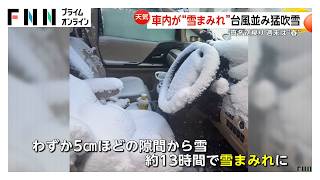
A photo taken in Sapporo on the morning of the 19th showed the inside of a car filled with snow. Snow had piled up on the driver’s seat and steering wheel, forming a mound inside the vehicle.
The owner explained that a small gap had been left in the window. “When someone drives, the car fogs up, so I always leave the window slightly open. I forgot to close it and didn’t realize until the morning.”
With a blizzard warning in effect, snow blew through a roughly 5-centimeter gap in the window, filling the car interior over about 13 hours.
Meanwhile, winter-like cold returned to the Kanto region. Around 1 p.m. on February 19th, snow was falling in Minakami, Gunma Prefecture, and about 5 centimeters had accumulated on benches since the previous night.
In Higashiagatsuma, Gunma, a massive ice wall formed as water seeping from a cliff froze, creating the “Nurukawa Ice Wall,” estimated to be about 100 meters wide and 20 meters high, according to Yume Shimizu of the town’s community development promotion section. Visitors commented, “It’s amazing what nature can create. It’s not something man-made.”
Temperatures in central Tokyo are expected to rise sharply over the three-day holiday starting on February 21st. On February 23rd, the Emperor’s Birthday, the forecast high is 19 degrees Celsius, comparable to late April.
Even in Hokkaido and the Tohoku region, where snowfall has been heavy, temperatures are expected to reach levels typical of April, prompting warnings about falling snow and avalanches.
Source: FNN
[embedded content]
Disclaimer : This story is auto aggregated by a computer programme and has not been created or edited by DOWNTHENEWS. Publisher: newsonjapan.com


