‘Hotter and hotter and hotter’ – Europe’s new climate in seven charts
 Image source, Tino Romano / EPA
-
Published
We might only be a few days into July, but two record-breaking summer heatwaves have already provided the UK and Europe with a snapshot of their new climate.
Hot on the heels of May’s heat, June saw temperature records not only broken but smashed in what the UN’s weather agency called an “extraordinary” event across the continent.
And after a brief period of respite, another heatwave is on the way.
If this feels unusual, that is because it is. But it is also exactly what scientists predicted in our warmer world, driven primarily by the burning of fossil fuels releasing heat-trapping greenhouse gases into our atmosphere.
“Human-induced climate change has made events like this more likely and more intense,” said Prof Stephen Belcher, chief scientist at the UK Met Office.
The intensity of these heatwaves is evident from how far temperatures were above normal in May and June averaged across the UK, marked here in red.
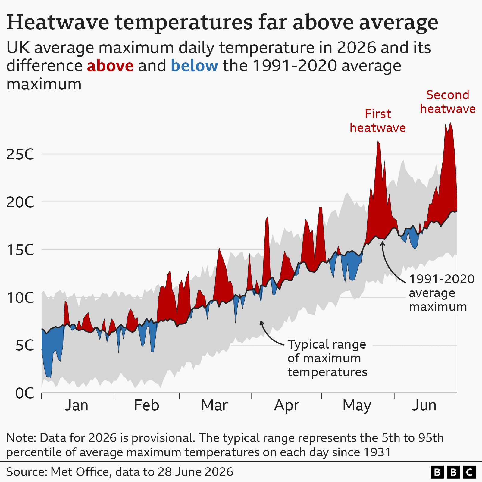
While the June heat was strongest in southern England and south Wales, few areas escaped the warmth.
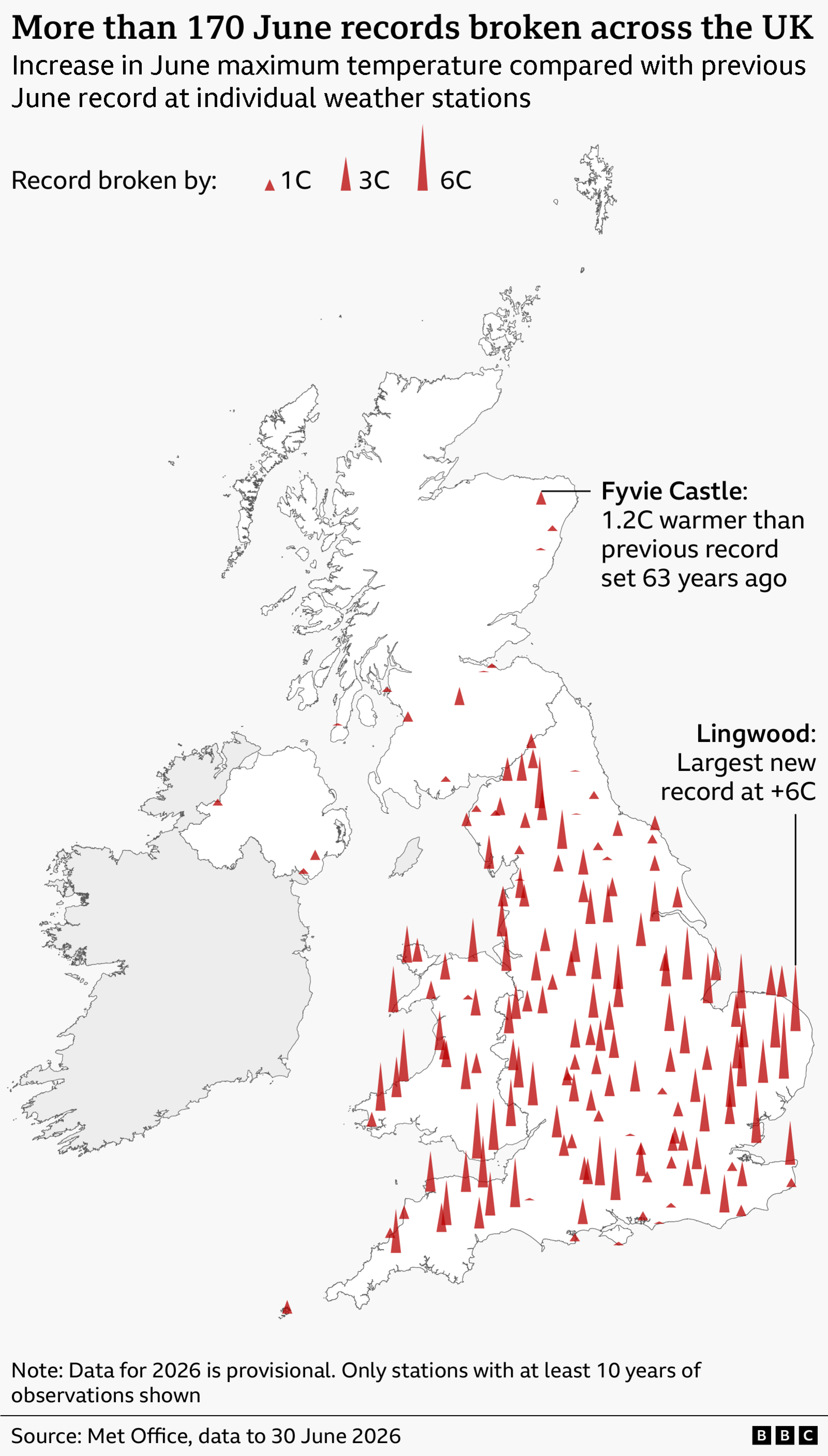
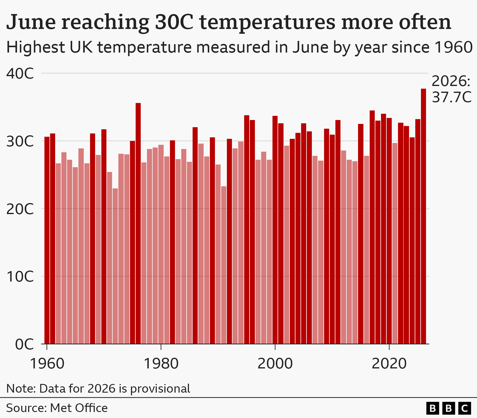
Temperatures peaked at 37.7C in Lingwood, Norfolk, according to provisional figures. It was one of several stations to surpass the UK’s previous June high of 35.6C, set in 1957 and tied in 1976.
“To see temperatures like this in the UK in June is sobering,” said Belcher.
Not every weather station has data as far back as the famous summer of 1976, but even some of the longest-running stations saw their previous records broken by 2C or more.
“We normally expect the records broken by small amounts – tenths, maybe up to a degree or so,” said Ed Hawkins, professor of climate science at the University of Reading.
“So to have it shattered by such a large amount is noticeable and extraordinary, and of course this comes after a similar event in May.”
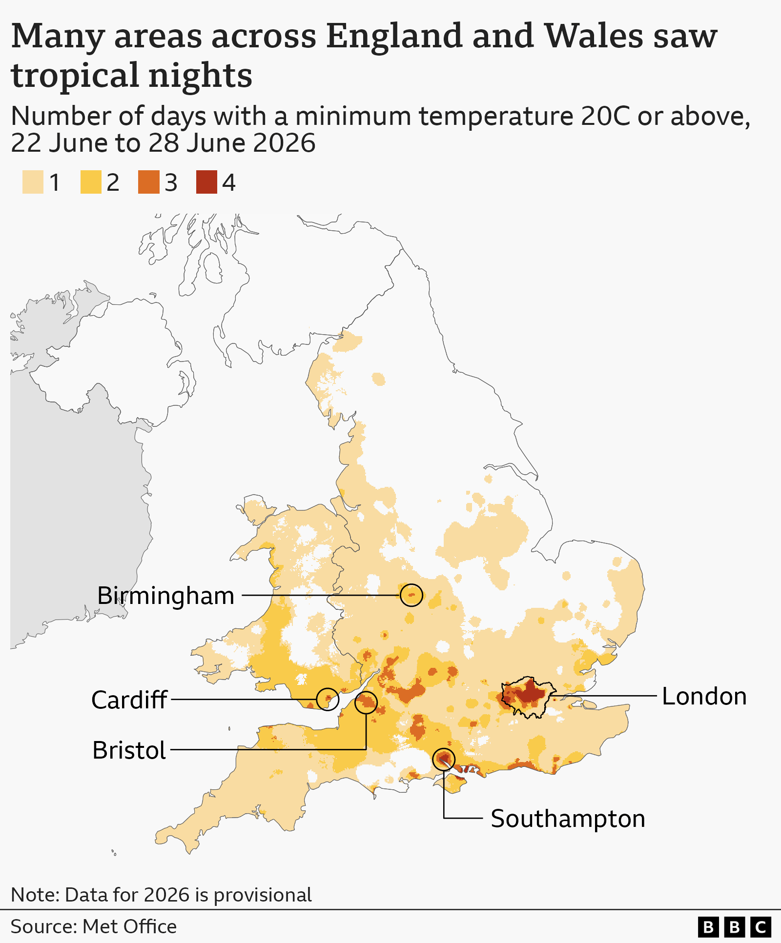
June’s heatwave may have felt particularly oppressive because it brought a double whammy of high temperatures and humidity. High humidity means it is harder for our bodies to cool down by sweating.
It also stayed very warm even after the Sun had set, making it difficult to sleep. Our bodies rely on cooler nighttime temperatures to recover from the heat of the day.
In Cardiff, temperatures did not drop below 23.5C on the night of Wednesday 24 June into Thursday – the warmest June night ever recorded around the UK.
Most of England and Wales experienced at least one tropical night in June, where temperatures do not fall below 20C. Historically, these have been very rare in the UK.
“We would definitely expect to see more and more tropical nights, as global temperatures keep rising,” said Hawkins.
The same “heat dome” that brought extraordinary heat to the UK in June also saw records tumble across Europe.
The German weather service, Deutscher Wetterdienst, named it “a heatwave for the history books”. The French weather agency, Météo-France, described it as “exceptional” and “historic”.
More than a dozen countries across western, central and eastern Europe broke their June temperature record – with gaps of up to two or three degrees between old and new highs.
Some countries faced temperatures above 40C and set a new record for any time of year – even though June is typically cooler than July.
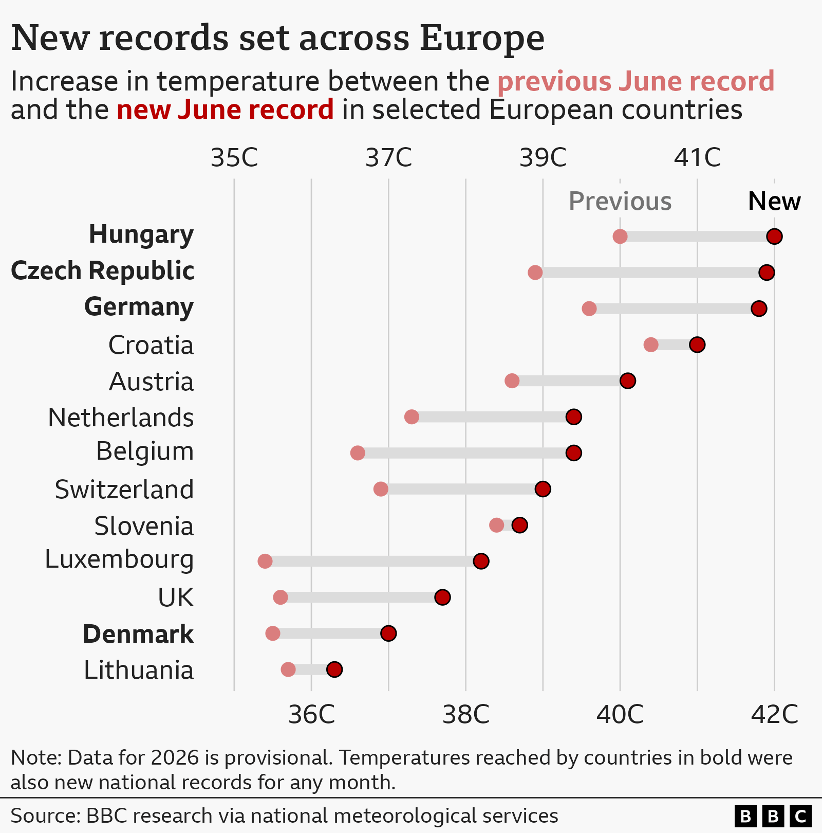
France and Spain also recorded their hottest June days in terms of a national average, although higher temperatures had been reached before at individual weather stations.
“Compared to historical measurements, this was obviously very unusual,” said Sonia Seneviratne, professor at the Institute for Atmospheric and Climate Science at ETH Zurich in Switzerland.
The Alpine nation reached 39C, surpassing the previous June record by more than 2C.
“[But] I would say as a climate scientist, I was not that surprised to see this happen… when you know that we have a warming climate,” she added.
Global temperatures have been rising over the past century due to humanity’s emissions of greenhouse gases, but local or regional geography shapes the speed at which different places are warming.
And as Europe is warming particularly quickly, it is more exposed to frequent and stronger spells of extreme heat.
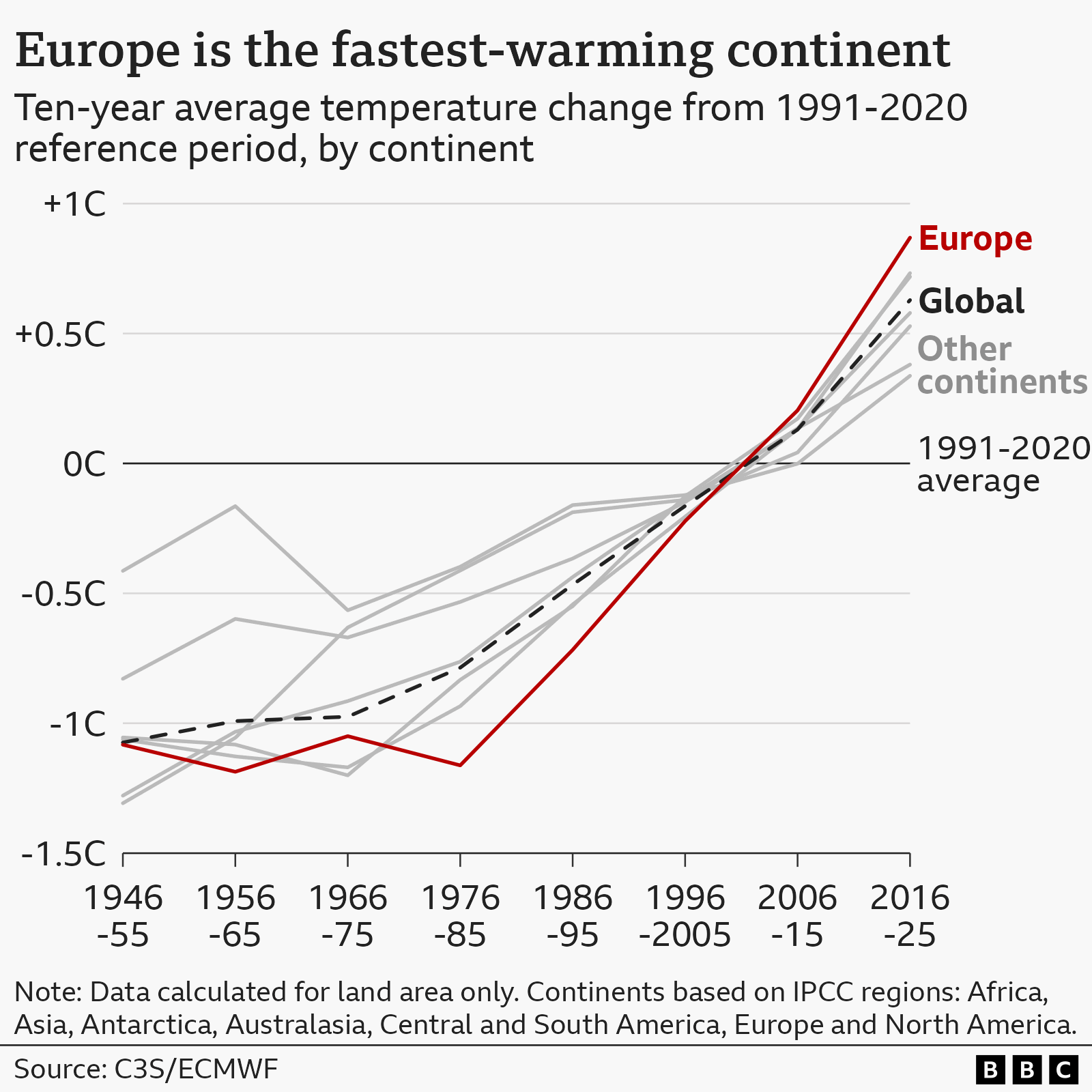
Europe’s rapid warming is partly the result of the melting of bright snow and ice, and a drop in the number of tiny polluting particles in the air. This means that less of the Sun’s energy is reflected back into space, leaving more energy to heat the Earth’s surface.
Some scientists also argue that the warming climate may be changing atmospheric circulation patterns around Europe in a way that brings more of the high-pressure systems that can lead to heatwaves, although this is not certain.
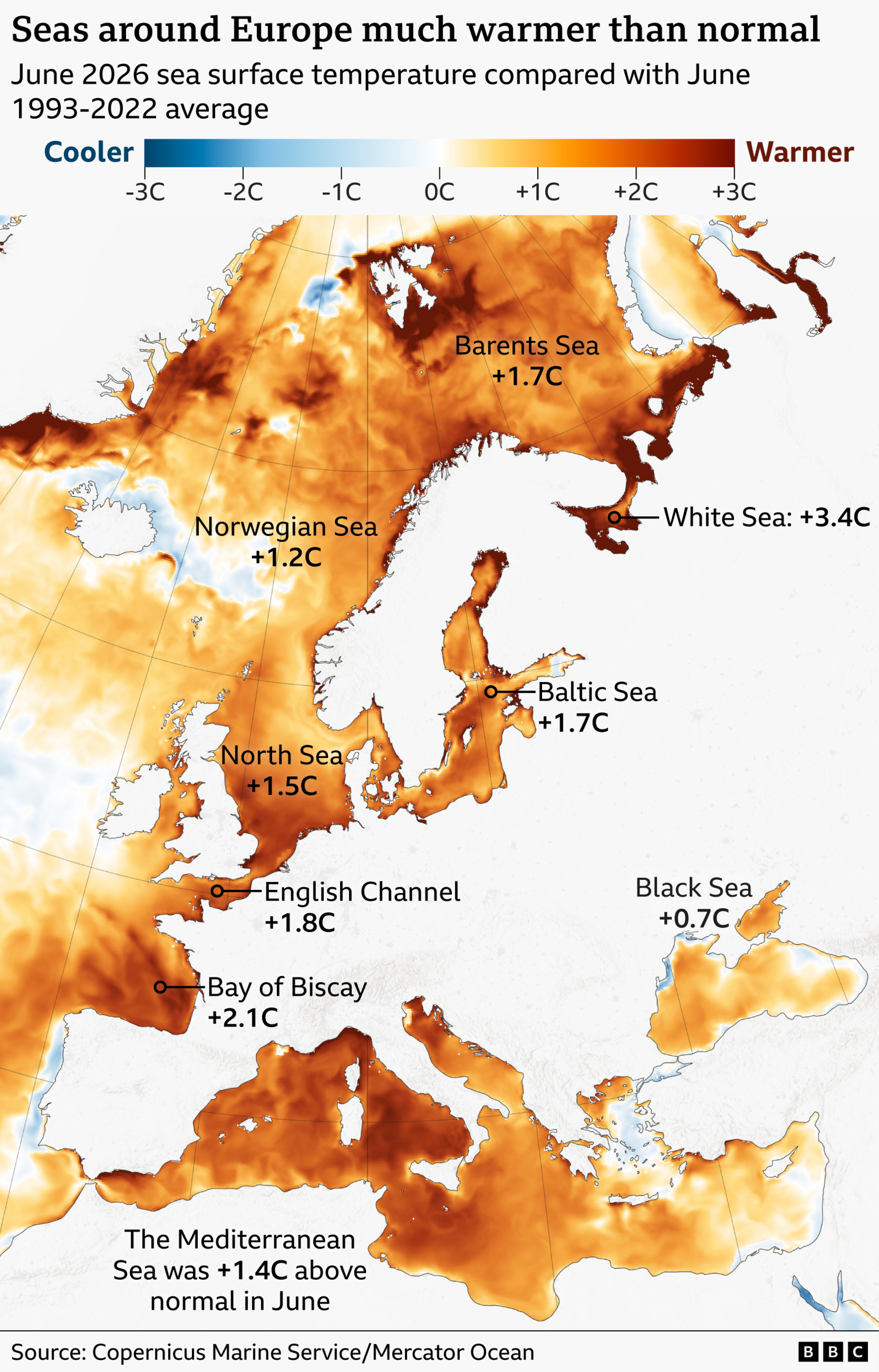
Europe’s seas are exceptionally warm this summer too. Marine heatwaves conditions around the UK’s coast have strengthened partly because of last week’s record-breaking air temperatures.
But as water takes longer to cool down than the air, sea heat can be longer-lasting. This can help to intensify future heatwaves on land by reducing the cooling effect from sea breezes.
Scientists are certain that climate change has already made warm spells like the June heatwave significantly hotter than the same weather systems of the past.
“The only way to explain [such strong heatwaves] is to taking into account this [long-term] warming,” said Seneviratne
“When you have a high-pressure system, this heatwave will tend to be much hotter [now]. This is very well understood.”
And scientists warn that as average temperatures continue to rise, hot spells of the future will be able to reach even higher temperatures.
Only a few decades ago, the UK reaching 30C in June was a relatively rare event. Now it has become the norm.
The long-term warming trend across the UK and Europe does not mean that the next heatwave will be hotter than the last, nor that next summer will necessarily be hotter than this one.
But scientists warn that UK and European summers will inevitably keep getting warmer on average as carbon emissions continue to heat up the planet.
“Our heatwaves will get hotter and hotter and hotter until we get to global net zero greenhouse gas emissions [and] we stabilise the climate,” said Hawkins.
-
Third heatwave for parts of the UK is on the way as 30C temperatures are forecast
-
Published15 hours ago
-
-
The UK’s summers are getting hotter – but how prepared are we?
-
Published24 June
-
-
A really simple guide to climate change
-
Published14 January
-
-
How climate change worsens heatwaves, droughts, wildfires and floods
-
Published5 November 2025
-

Sign up for our Future Earth newsletter to keep up with the latest climate and environment stories with the BBC’s Justin Rowlatt. Outside the UK? Sign up to our international newsletter here.
Disclaimer : This story is auto aggregated by a computer programme and has not been created or edited by DOWNTHENEWS. Publisher: newsrss.bbc.co.uk