HYDERABAD: India could well be heading into weather rougher than predicted, with all signs pointing to an even worse southwest monsoon than what was forecast earlier this month by the India Meteorological Department.
The first long-range forecast by the IMD on April 14 predicted the monsoon rainfall this year to be 92 per cent of the long period average (LPA) with a plus or minus 5 per cent possibility. The normal LPA as per IMD, based on rainfall data between 1971 and 2020, was 87 cm. At the predicted 92 per cent, the country would get 80 cm of rain during the June-July-August-September (JJAS). If the plus-5 per cent happened, it would be 84.35 cm of rain.
However, the meteorological community is now worried that all indications are pointing to an even poor monsoon. The El Nino phenomenon over the central Pacific Ocean, which typically impacts the monsoon, for all practical purposes is already in place, much earlier than expected. The saving grace for the monsoon, the Indian Ocean Dipole (IOD) over the Arabian Sea, which meteorologists hoped would turn positive sometime in July-August, is now expected to do so, if at all, only after the monsoon season officially ends in September.
It is reliably learnt that when the IMD issues its next and final second stage long range forecast before the end of this month, it is likely to revise its initial predictions by factoring in the El Nino formation, and the delayed IOD turning positive from its current neutral phase.
“This will mean even less rain than what was hoped for. We could well be staring at a drought-like year in several parts of the country,” a source said.
The El Nino is expected to be a strong event this year, with some meteorologists already calling it a possible ‘super’, and ‘historic’ event. “The real worry is what if El Nino conditions continue into the beginning of the next monsoon season. If that happens, we do not know what might happen, though there is no certainty at all on how things will shape up by then,” a meteorologist said.
Historically, the El Nino phenomenon lasts nine to 12 months. If the formation of El Nino this year becomes official sometime in June or July, then it could still be around by the time next year’s monsoon season rolls in.
June to be the best of the worst, September to sting
The 2026 monsoon season could see not just a slow start in terms of rain but one that could end with a whimper.
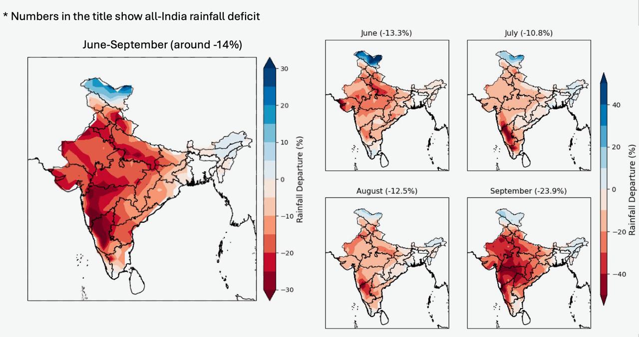
“There is a super high confidence in the El Nino formation. The climate models would not have been strong last month, but current models are indicating that the overall departure from normal rainfall in the June-July-August-September (JJAS) period will be around 14 per cent,” Dr Akshay Deoras, a research scientist at the National Centre for Atmospheric Science & Department of Meteorology, University of Reading, UK, told Deccan Chronicle on Tuesday.
He said predictions based on the UK Met Office, the European Centre for Medium-Range Weather Forecasts, and the National Centers for Environmental Prediction of US’ National Oceanic and Atmospheric Administration, pointed to a further degraded monsoon season.
While each of the four monsoon months are expected to end up with deficit rainfall, June might be the one with 13.3 per cent deficit which will be the least, September, bringing up the rear of the JJAS season, will be the sting in the monsoon season’s tail with a likely deficit of a whopping 23.9 deficit. The three models based on which these predictions are made point to a further weakened monsoon, Dr Deoras said.
Don’t hold your breath for rains, govt tells farmers
The Centre has cautioned farmers not to give in to anxiety over the start of the monsoon this year, saying that the fact was that rain does not begin the same time every year in every place.
In a message titled ‘Information for farmers’ that was sent to PM Kisan scheme beneficiaries on Tuesday, the government said farmers may receive messages about when rain may occur in their areas. However, the government also said: “Please take notice” that it is not necessary that the regular rainy season in any region begins at the same time every year.
The notice incidentally came just ahead of the India Meteorological Department’s second and final monsoon season prediction which is expected to be issued any time before the end of this month.
Heat dome set the stage – now hot winds from north keeping state sizzling
First it was a heat dome that resulted in Telangana getting baked with sustained high temperatures over the past fortnight. Now, it is the north westerlies that are pumping in hot air, not allowing any room for the air to cool down, and the current conditions are expected to stay in place for a few more days.
Only the southern circumference of the heat dome, an upper air circulation, was over north Telangana but that was enough to keep the hot air from rising up into the atmosphere and dissipating heat. “The dome formed around May 19 and dissipated on May 23, and this hot circulating mass of air with nearly 500 to 600 km diameter, sat like a lid over northern Telangana, central and north western India, acting like a lid and preventing the head from dissipating,” Dr G.N.R.S. Srinivas explained.
“The hot air over the ground had nowhere to go other than sideways, and this resulted in hot winds blowing sideways adding to the already hot conditions,” Dr Srinivas said.
Though the ongoing heatwave conditions made it appear that the state was experiencing a rare event, Dr Srinivas said that what Telangana was facing currently fell in the ‘normal’ summers category going by temperature records over the last 30 to 40 years. “However,” he explained, “if the heat ‘feels’ much hotter than last year, or the last few years, then people are right. This summer is hotter than what the state experienced between 2020 and 2025, with these years experiencing milder summers.”
He also said that this year’s summer seemed particularly hot because of the sustained heat over 10 days or more. “The consistency of high temperatures was first because of the heat dome, and now because of the hot north westerlies bringing in heat from Rajasthan and Central India into Telangana. This kind of sustained heat is not normal for the state,” Dr Srinivas said.
Meanwhile, the IMD has said that the heatwave conditions will continue over Telangana for the next few days, with red and orange alerts in place for several districts over the next three days.
Disclaimer : This story is auto aggregated by a computer programme and has not been created or edited by DOWNTHENEWS. Publisher: deccanchronicle.com