
There’s an old sayingthat suggests “there’s no such thing as bad weather, only unsuitable clothing.” But the truth is that walking in dismal conditions can be soul-sapping or downright dangerous.
Some trails are accessible or safe only when high mountain passes are snow-free, or when paths aren’t quagmires mid-monsoon.
So, it pays to know when’s best to stride out. And that’s not always about sun or rain: it can be worth hiking outside what’s typically deemed the “best”, sunniest or driest period to bag discounts, catch a seasonal wildlife spectacle or dodge crowds.
Of course, your “when” may be fixed, such as when you can take time off work.
To help you decide where and when to spend your precious leave, here is a selection, from Lonely Planet’s new book, Where To Go When: Hiking, showcasing, month by month, some of the world’s greatest walks with each containing routes of varying durations and difficulty.
Sign up for the Traveller Deals newsletter
Get exclusive travel deals delivered straight to your inbox. Sign up now.
Let’s roll.
JANUARY
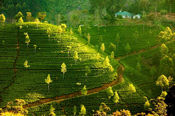
Where Pekoe Trail, Central Highlands, Sri Lanka
Start Hanthana Finish Nuwara Eliya
Distance + duration 323 kilometres, 10-22 days
Difficulty 3/5
Stay Hotels, homestays
Sri Lanka’s newest long-distance hike could be just your cup of tea with Pekoe, after all, being a high-grade black tea made with young leaves plucked from plants in Sri Lanka’s Central Highlands. The route of the Pekoe Trail winds through tea country, exploring its landscapes, history, culture, food and, of course, drink. It’s a little over two centuries since British colonialists recognised ideal tea-growing conditions here with the first plantation established at Loolecondera in 1867 by Scotsman James Taylor. Tracks and footpaths were created to enable these workers to access the plants, and to transport tea to train stations and on to capital Colombo for shipping. By linking these, modern-day Spanish expat Miguel Cunat wove together the 22-stage Pekoe Trail, aiming to encourage visitors to discover rural life, bring incomes to small highland communities, and meet villagers and tea artisans who pick and produce the tea. It’s more enjoyable with a guide and most comfortable before late April, when the monsoon rolls in and temperatures climb. See thepekoetrailsrilanka.com
FEBRUARY
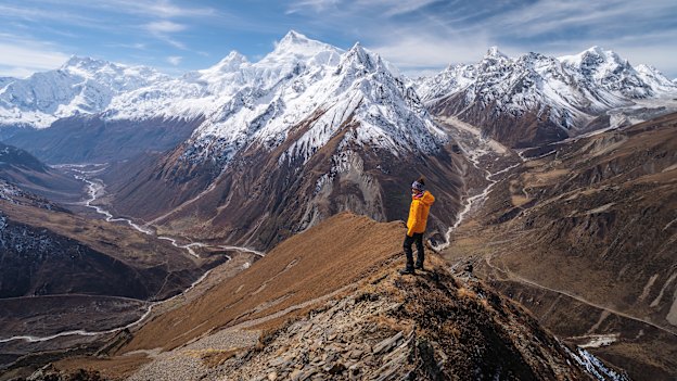
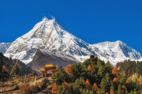
Where Manaslu Circuit, north-central Nepal
Start Machhi Khola Finish Jagat
Distance + duration 175 kilometres, 12 days plus acclimatisation days
Difficulty 5/5
Stay Simple teahouses (lodges)
Trek between Tibetan Buddhist villages and Himalayan summits, through bamboo forests, across yak-grazed meadows and over lung-busting passes in a remote and magical region during October to November and February to April. The first rays of the rising sun catch the highest peak on the horizon. Twin fangs glow fiery red then pearly white: a beacon, a challenge, a dream. This is Manaslu, the world’s eighth-tallest peak at 8163 metres and the fulcrum of an epic trekking circuit that wheels through some of Nepal’s most inspiring and diverse landscapes and settlements. Trekkers seeking these marvels, but eager to sidestep the masses that throng better-known routes – particularly Everest Base Camp and Annapurna Circuit – are only now discovering the spectacular and gloriously diverse loop winding around Manaslu, a little south-east of the Annapurna massif. Since the devastating earthquake of 2015, relatively comfortable teahouse lodges have opened, yet the paths are quiet, even during peak trekking season See ntb.gov.np
MARCH
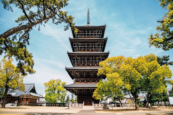
Where 88 Temple Pilgrimage, Shikoku, Japan
Start and finish Ryozen-ji
Distance + duration 1200 kilometres, 40-50 days
Difficulty 3/5
Stay Hotels, minshuku (B&Bs), ryokan (inns), shukubo (temple stays), zenkonyado (free or low-cost pilgrim lodgings)
This island-looping long-distance trail between a series of sacred Shingon Buddhist temples is an epic walk that provides insights into Japanese culture and beliefs. Shikoku Pilgrimage, which completes a circuit of Japan’s fourth-largest island, is designed to visit the 88 temples that represent the 88 evils of human life. The starting point is not relevant, so long as a full circuit is completed. Formalised in 1687, the route tends to begin these days at Ryozen-ji, in Shikoku’s north-east. Many aruki henro (walking pilgrims) don’t complete the whole route in one go, but choose to employ the kugiri-uchi method which covers the pilgrimage in stages, sometimes over several years, or perhaps ticking off the legs in the island’s four prefectures – Tokushima, Kochi, Kagawa, Ehime – over four trips. Many even undertake the pilgrimage by riding aboard a popular henro bus. See henro.org
APRIL
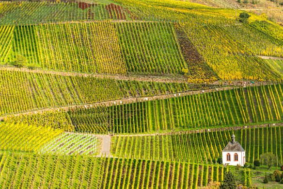
Where Moselsteig, Moselle Valley, Germany
Start Perl Finish Koblenz
Distance + duration 365 kilometres, 14-24 days
Difficulty 3/5
Stay Guesthouses, B&Bs, hotels, campsites
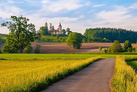
Plot a grape escape along the meandering Moselle River among vineyards, castles and Roman remains of this historic winemaking region. The Roman impact on swathes of Europe is evident by not just mighty amphitheatres, walls, gates and temples – though you’ll find those along the Moselle Valley – but also winemaking, which they introduced to the region two millennia ago. The results are visible almost everywhere: signs advertise a weingut (winery), weinprobe (wine tasting) or weinverkauft (wine for sale) around every corner. The Moselle is one of Germany’s great white wine regions and this walking route mostly follows the river from the three-way France-Luxembourg-Germany border at Perl to the confluence with the Rhine at Koblenz. Not too long after setting out, beyond the limestone Nittel Cliffs, the trail arrives in Trier, or, as the Romans named it, Augusta Treverorum, once the largest city north of the Alps. See en.visitmosel.de/hiking
MAY
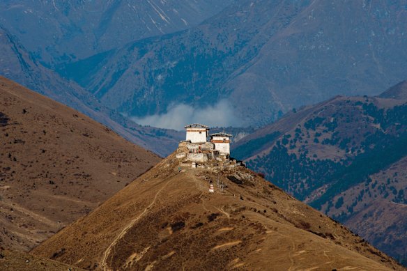
Where Jomolhari Trek, Bhutan
Start Shana Finish Dolam Kencho
Distance + duration 85 kilometres or longer, 6-8 days
Difficulty 4/5
Stay Tents on trek route, hotels at either end
Trek through the monumental wilderness of Jigme Dorji National Park in this long-secluded Himalayan kingdom, looking out for yaks and – if you’re really lucky – an elusive snow leopard. Dubbed the Kingdom of the Thunder Dragon, until the 1970s this compact, long-isolated Himalayan nation was off-limits to foreign visitors. Since then, it has kept tourism to a minimum, however access has become easier and a little cheaper in recent times. Bhutan’s epic mountain landscapes, burly dzongs (fortress-monasteries), unique costumes and customs remain as enthralling as ever. Head to the high trails and you’ll discover an untamed world of 7000 metres-plus summits, remote villages and rare wildlife. Come in spring to dodge winter’s deep chill and summer rains. Though the Jomolhari Trek route, named after the 2700-metre Himalayan mountain that straddles the border between Tibet, China and Bhutan, can be completed in around a week, logistics – and common sense – mean you’ll bookend your hike with at least a day or two experiencing the marvels of Paro, home to the international airport, and the capital Thimphu, as well as a climb to the world-famous, cliff-clinging Tiger’s Nest Monastery. See bhutan.travel
JUNE
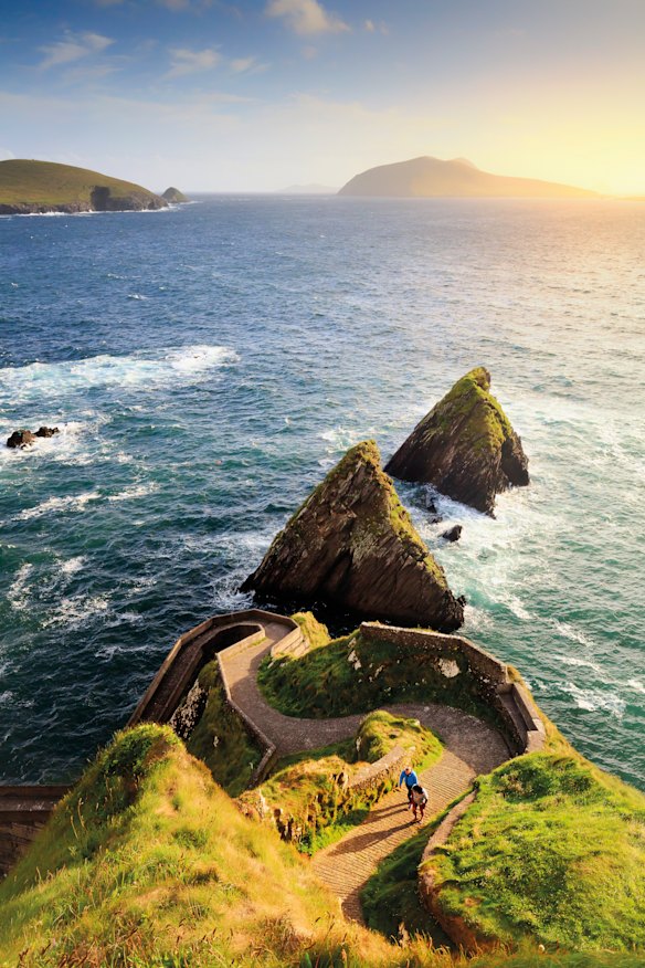
Where Dingle Way, County Kerry, Ireland
Start + finish Tralee
Distance + duration 179 kilometres, 6-10 days
Difficulty 2/5
Stay B&Bs, hotels, glamping, camping
Thrusting out into the crashing Atlantic waves, the Dingle Peninsula is home to some of Ireland’s finest scenery – and one of its greatest walks. Corca Dhuibhne, the Dingle Peninsula, is Ireland’s wildest west, a rugged finger poking out into the Atlantic at the extreme edge of Europe. The well-marked Dingle Way, beginning and ending in the town of Tralee, circuits the peninsula. It passes lively towns, archaeological sites, emerald meadows, relatively formidable peaks, ocean-smacked cliffs, restaurants serving succulent seafood and wonderful old pubs. Rarely too taxing, the most challenging aspect is the changeable weather, so a visit in late spring or early summer is best for drier, warmer conditions. June in particular offers near-endless days – more than 18 hours of daylight on the summer solstice – but sits just before the peak season, making it easier to secure accommodation and to spy dolphins, minke whales or even humpbacks from clifftops. See thedingleway.ie
JULY
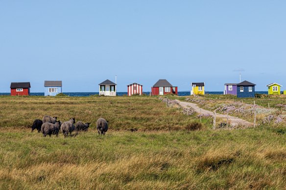
Where Archipelago Trail, Fyn Archipelago, Denmark
Start Faldsled, Fyn Finish Soby, Aero
Distance + duration 220 kilometres, 7-14 days
Difficulty 1/5
Stay Broholm Castle guesthouse, network of free or cheap camper-friendly shelters
Wend your way around under-sung but idyllic Fyn (pronounced “foon”) and its outlying islands, hopping over the Baltic Sea by boat and bridge. Sitting between Zealand and Jutland, the island of Fyn is considered the country’s kitchen garden, liberally spread with wheat fields, dairy farms and fruit trees. Sprinkled with moated and turreted castles and manors, it’s fringed by golden sand and cute fishing villages. Fyn is particularly lovely during the long, lazy days of the Scandi midsummer, when the Baltic Sea is still brisk but bearable for swimming. The Archipelago Trail, one of Denmark’s longest hiking routes, is not really one path but a series of seven interconnected trails that weave around Fyn’s southern shores and islands, within the South Fyn Archipelago UNESCO Global Geopark. This is a “drowned” landscape, created when water levels rose after the last Ice Age, and where only the highest hills nose above the surface, forming the 55 islands and islets dotted hereabouts. See visitfyn.com
AUGUST
Where Luznice Valley Trail, Bohemia, Czech Republic
Start Plana nad Luznici Finish Tyn nad Vlavou
Distance + duration 55 kilometres, 4 days
Difficulty 2/5
Stay Hotels, cabins, guesthouses
Toulava, the area through which the Luznice Valley Trail passes, is derived from the Czech word “toulat” which means to roam unhurriedly through the countryside, imbibing its wonders. It sits at the edge of Bohemia, a landscape of thick forests, rolling hills, attractive towns and the green, winding valley of the Luznice River. The latter is the lodestar for this largely gentle hike that’s rated as one of the continent’s best. Summer is its busiest and hottest time, but there is a lively buzz and the heavily forested hike offers plenty of shade. The trail is split into four stages. The first links the town of Plana nad Luznici with historic, castle-topped Tabor, founded in the 15th century; the second stage becomes steeper and rockier as it wends via old mills, rock tunnels and the ruins of Pribenice Castle; the final two stages squeeze through an ever-narrowing gorge passing ruined Dobronoce Castle and crossing the elegant Rainbow Bridge and finishing on the water’s edge in Tyn nad Vltavou. See visitczechia.com
SEPTEMBER
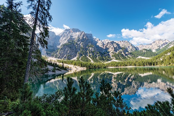
Where Alta Via 1, Dolomites, Italy
Start Lago di Braies Finish La Stanga, Belluno
Distance + duration 120 kilometres, 8-12 days
Difficulty 3/5
Stay Shared dorms in rifugi (mountain huts)
Alta Via 1 is well named. It’s an alta via – high road – both literally and metaphorically, offering soul-lifting trekking through the dazzling Dolomites. Rugged but not frighteningly tough, it’s a good option for alpine first-timers. There are dramatic ramparts of limestone and dolomitic rock, passes reaching up to 2752 metres, meadows festooned with wildflowers, welcoming rifugi (mountain huts) dishing up hearty portions of fine food and bonhomie, and even thrilling (but not too scary) sections where metal handrails help you negotiate the wild terrain. The alpine summer, from mid-June to late September, is really the only time to walk this classic route. It’s when the trails are largely snow-free, when the huts are open, when wildflowers bloom and when squeaking marmots are out of hibernation. All the while, the Dolomites unfurl majestically. Many claim that these are Europe’s best-looking peaks, and every footstep opens up another gorgeous view. See dolomiti.org
OCTOBER
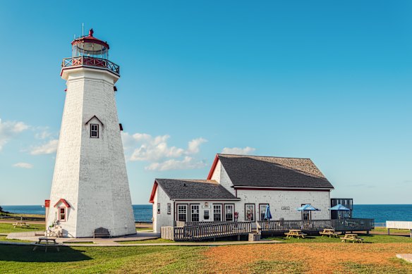
Where Island Walk, North Shore, Prince Edward Island, Canada
Start Kensington Finish Elmira
Distance + duration 163 kilometres, 7 days
Difficulty 3/5
Stay Inns, B&Bs, guesthouses and hotels, campsites
Soak up some autumnal glory with a north-coast hike on the bucolic island that inspired Lucy Maud Montgomery’s Anne of Green Gables novels. Early autumn, when trees blaze with turning foliage, is the time to trek the trail. While the full circuit takes about a month to complete, a week’s walking along the north shore ticks off many of Prince Edward Island’s highlights. From Kensington, roll through patchwork farmland to the village of New London, Montgomery’s birthplace. Beyond lies Cavendish, where you’ll find the author’s former home, Green Gables (now a national historic site), and the throwback village of Avonlea. Beyond that, there is also Rustico, the island’s oldest French colonial settlement, dating from the 18th century. Then it’s east into Prince Edward Island National Park, strolling the sandy shoreline past harbours and lakes, alongside marshes and through forests. Watch for teal and ring-necked ducks as you pass Black Pond Migratory Bird Sanctuary before finishing at East Point Lighthouse. See theislandwalk.ca
NOVEMBER
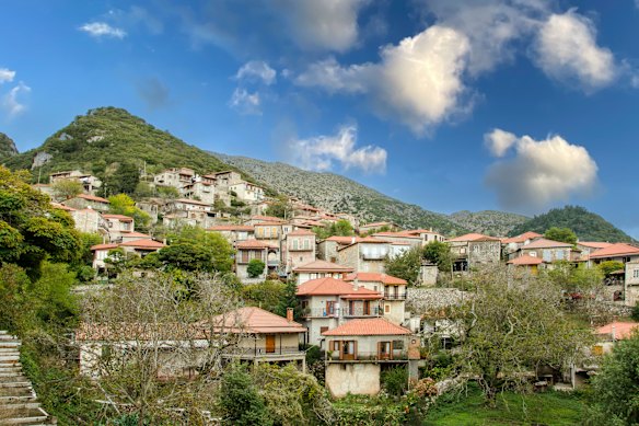
Where Menalon Trail, Peloponnese, Greece
Start Stemnitsa Finish Lagkadia
Distance + duration 75 kilometres, 4-5 days
Difficulty 2/5
Stay Hotels, guesthouses, rooms in villages en route
The Menalon Trail traverses the heart of the Peloponnese and passes through a land of age-old myths, singing shepherds and fertile valleys. The award-winning, well-signed and serviced walk is a social enterprise that aims to bring hikers (and their euros) to this rural region. This far south in Europe, temperatures remain pleasant for walking while autumn colours shine; you might even catch the end of the grape harvest. The trail winds around the western edge of 1981-metre Mount Menalon, the legendary home of Pan, god of nature, shepherds, flocks and mountain wilds. Using a network of timeworn paths and mule tracks, the trail is broken into eight sections; most hikers tackle it in a northward direction, taking four or five days to walk from Stemnitsa, known as the goldsmiths’ village, to Lagkadia, the stonemasons’ village. Along the way lie old stone settlements perched on hillsides, dramatic limestone folds, forests of fir and pine, small country churches and steep-sided valleys. See menalontrail.eu
DECEMBER
Where Rakiura Track, Stewart Island/Rakiura, New Zealand
Start Lee Bay finish Fern Gully (or vice versa)
Distance + duration 32 kilometres, three days
Difficulty 2/5
Stay Simple park huts with bunks, basic campsites, lodges, B&Bs
Many come to Stewart Island/Rakiura, New Zealand’s third-largest island, located 30 kilometres south of the South Island across the Foveaux Strait at the bottom of the South Island, to hike what is designated one of the nation’s Great Walks. Yes, it’s magnificent and it’s also relatively short. There are no really challenging climbs with the highest elevation only about 200 metres and daily distances are all well under 15 kilometres. Yet within this modest mileage you can savour the natural, scenic, cultural and historic delights of this isle, which is home to more kiwis (15,000 to 20,000) than humans (440). The avian fauna isn’t the only aspect that’s wild on Rakiura: lying slap in the Roaring Forties latitude, its weather is unpredictable. Come in summer, when days are longer and conditions more likely to favour hiking, but prepare for any eventuality and you can enjoy the experience year-round. See newzealand.com
This is an edited extract from the new Lonely Planet book, Where To Go When: Hiking, $44.99. See shop.lonelyplanet.com
FIVE EPIC AUSTRALIAN HIKES
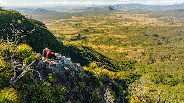
Scenic Rim Trail, Qld
Plunge into the world’s largest subtropical rainforest on a four-day trek (best tackled between April and September) through Gondwana’s geological and biological history. It’s a challenging hike for even the strongest legs. See parks.qld.gov.au
Cape to Cape Track, WA
Tramp the epic shoreline of Australia’s far south-west year-round, hiking this 135-kilometre trail between the region’s historic lighthouses as spring wildflowers bloom and whales cruise offshore. See trailswa.com.au
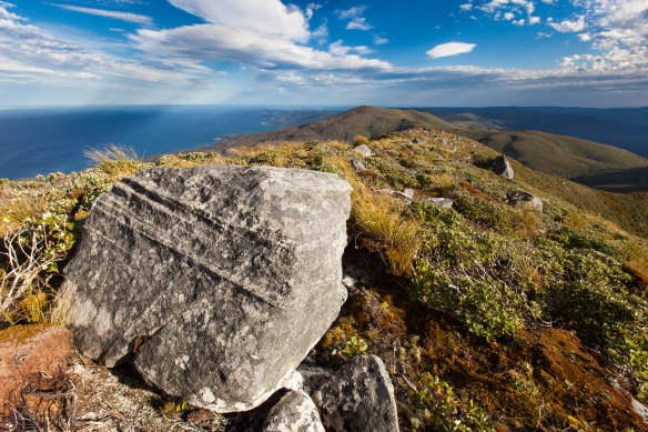
Grampians Peak Trail, Vic
Take on Gariwerd, the Indigenous word for the Grampians meaning “big mountain”, on a challenging, 13-day hike amid the wild beauty and ancient Aboriginal culture of the mighty 1672 square kilometres Grampians National Park. See parks.vic.gov.au
Kangaroo Island Wilderness Trail, SA
Enjoy spring shoots and regenerating bushland following the devastating bushfires of 2020 on an official 66-kilometre, five-day walk across this wildlife-rich island. See parks.sa.gov.au
Snowies Alpine Walk, NSW
One of the newest multi-day Australian treks, this four-day walk traces a high path through NSW’s Snowy Mountains where you can conquer a succession of summits, including the nation’s tallest peak, Mount Kosciuszko. See nationalparks.nsw.gov.au
Disclaimer : This story is auto aggregated by a computer programme and has not been created or edited by DOWNTHENEWS. Publisher: www.smh.com.au


