Tropical Storm Isaias forecast to become first Atlantic hurricane of 2026
-
Published
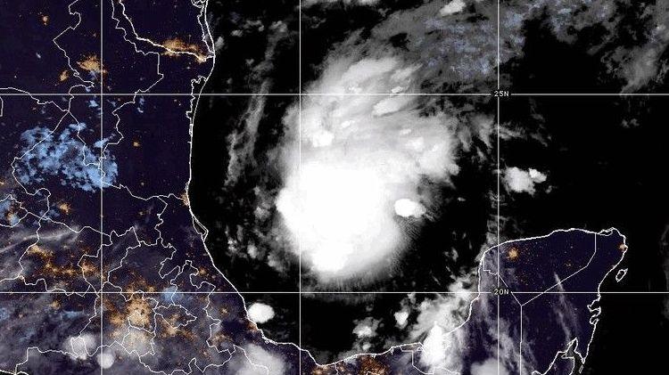
Tropical Storm Isaias has formed in the Gulf of Mexico and looks likely to strengthen into the first Atlantic hurricane of this year.
It is expected to reach hurricane strength late on Wednesday or early Thursday with forecasts suggesting it could then intensify to a category two storm.
It has the potential to bring damaging winds, torrential rain and a storm surge to parts of the US Gulf Coast with landfall expected on Friday or Saturday. Parts of Mexico could also see gusty winds and heavy rain as the storm moves northwards and eastwards.
Isaias will bring an end to the lack of hurricanes that has led so far to a record-breakingly quiet Atlantic season with development suppressed by the historic El Niño that continues to grow in the Pacific.
How strong will Isaias get?
In its latest update, the US National Hurricane Center estimates that Tropical Storm Isaias will strengthen rapidly and is likely to reach hurricane strength during Wednesday night. It will intensify further to a category 2 storm by Friday morning.
Parts of Mexico will feel the first impacts as the storm swirls out at sea, with 4in (100mm) of rain possible around the Bay of Campeche and the Yucatan Peninsula, accompanied by strong winds.
Isaias will then make landfall on the Gulf Coast – probably in Mississippi, Alabama or Florida – late on Friday or early on Saturday.

Forecasters predict that 3-6in (75-150mm) of rain could fall across the Gulf Coast, from south-east Louisiana to the north-west of Florida.
A few places could see up to 10in (250mm) with possible flash flooding, especially in urban areas, and the risk of isolated river flooding.
Dangerous winds are anticipated with the chance of a storm surge which could inundate low-lying coastal areas.
The US National Weather Service says it expects to issue Hurricane and Storm Surge Watches later on Wednesday with Florida Governor Ron DeSantis declaring a state of emergency across 25 north Florida counties over concerns about potential impacts.
As the storm moves further inland and loses contact with its warm water fuel source it will weaken but it is still expected to bring some potentially disruptive wet weather.
Between 1-3in (25-75mm) of rain is forecast for large swathes of the south-east USA – as far north as the Tennessee Valley and the Carolinas – with isolated totals of 5in (125mm).
 Image source, Cristobal Herrera-Ulashkevich/EPA-EFE/REX/Shutterstock
El Niño has lead to an eerily quiet hurricane season so far
Forecasters in the US predicted the 2026 hurricane season would be quieter than average due to the developing strong El Niño in the Pacific Ocean.
Eight to 14 named storms are forecast, three to six of which would become hurricanes, including one to three major hurricanes.
So far it seems this quiet forecast has come to pass.
Isaias is the ninth tropical storm of the Atlantic season, but will be the first to become a hurricane.
On 12 September the season set a new record for the latest date reached without a hurricane forming since the start of the satellite era in the 1960s. Almost another month has passed without one since then.
A major reason for this is the very strong El Niño that is continuing to intensify over the Pacific.
The heat released into the atmosphere by the very warm seas in the eastern tropical Pacific has weather impacts that ripple across the globe.
It can disrupt wind patterns above the Caribbean and the Atlantic leading to increased wind shear, meaning winds that blow at different speeds and directions at different levels in the atmosphere.
This can rip storms apart before they have time to strengthen.
However this is not the only factor that determines whether hurricanes will form. While it reduces the odds, it does not make it impossible – as Isaias proves.
Isaias has formed over the Gulf of Mexico where sea temperatures are currently 30-31C – around 2C higher than normal.
It is the warm ocean that gives hurricanes their fuel, providing energy and moisture allowing them to grow.
There is currently limited wind shear meaning the storm has chance to strengthen. However, wind shear is expected to increase dramatically in the 24 hours before Isaias makes landfall which may limit how intense it can become.
However the range of factors influencing hurricane development is complex and exact forecasts are likely to shift slightly over the coming days.
-
-
Published11 October 2024

-
-
-
Published21 August

-

Disclaimer : This story is auto aggregated by a computer programme and has not been created or edited by DOWNTHENEWS. Publisher: newsrss.bbc.co.uk