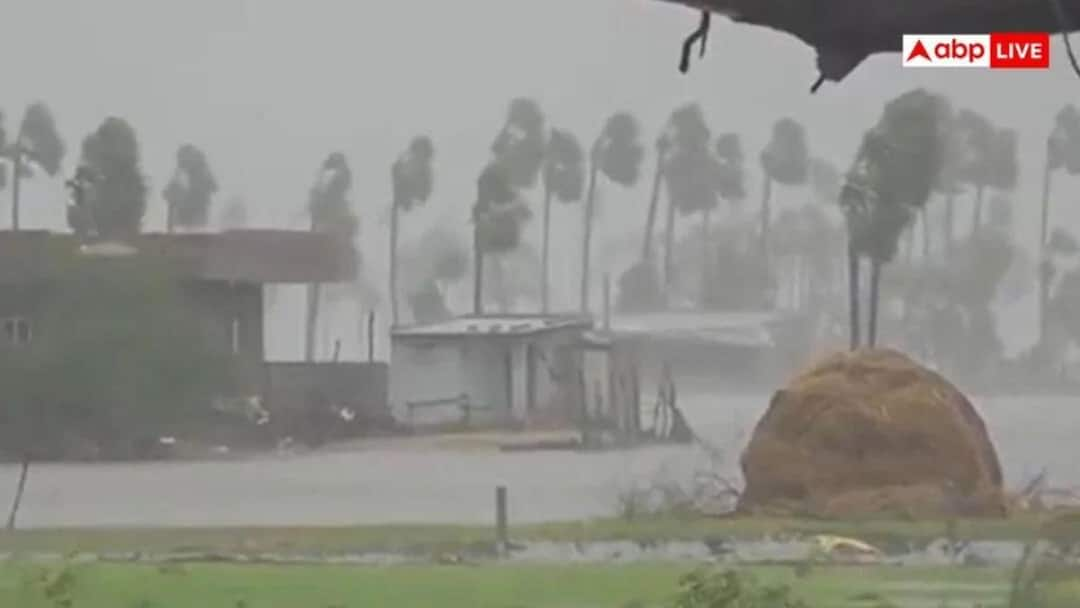
- Two severe cyclones hit Andhra Pradesh coast within five days.
- El Niño, warm oceans triggered this unusual back-to-back occurrence.
- IMD termed it a coincidence, not a new weather pattern.
- Cyclones caused damage, indirectly affecting broader national weather patterns.
The occurrence of two severe cyclones off the Andhra Pradesh coast within five days is unusual, but it does not indicate an established weather pattern. According to the India Meteorological Department (IMD), the back-to-back storms are a coincidence, with a combination of El Niño conditions, rising ocean temperatures and favourable atmospheric factors contributing to their formation.
Speaking to ABP News, IMD Director General Mrityunjay Mohapatra said the simultaneous occurrence of the two cyclones was random. He pointed out that this is an El Niño year and that October and November are typically active months for cyclonic activity. Rising sea surface temperatures have further contributed to conditions favourable for storm development.
On whether the cyclones would influence weather patterns in other parts of the country, Mohapatra said the storms would not directly affect the overall weather system. However, they could have indirect consequences because of the presence of a Western Disturbance over the country.
Two Cyclones Hit Andhra Pradesh Within Five Days
The first cyclone, Arnab, made landfall along the Andhra Pradesh coast as a very severe cyclonic storm between 2 am and 8 am on October 28. Wind speeds during landfall ranged between 125 and 135 kilometres per hour, with gusts reaching 150 kilometres per hour. It was the first cyclone of the year.
Five days later, on the morning of November 3, Cyclone Murasu crossed the coast near Ongole. The two landfall locations are approximately 268 kilometres apart in a straight line.
The closely timed landfalls have drawn attention to the unusual weather conditions over the Bay of Bengal and the factors that have made the region conducive to successive cyclonic systems.
How Strong Is This Year’s El Niño?
According to the IMD, El Niño conditions are currently prevailing over the Pacific Ocean and are expected to continue through November and December. The department estimates that strong El Niño conditions could persist until January-March 2027.
Data from the World Meteorological Organization (WMO) indicates that sea surface temperatures in the El Niño region were 1.6 degrees above normal in June before rising to 2.5 degrees in August.
Between October and December, temperatures are projected to remain around 3.7 degrees above normal. This would exceed the previous record of 2.6 degrees recorded during 2015-16.
The unusually warm ocean conditions are among the factors being monitored by meteorologists to understand the development and intensity of cyclonic systems.
What Does El Niño Have To Do With Cyclones Off Andhra Coast?
El Niño does not necessarily increase the number of cyclones forming over the Bay of Bengal. However, meteorologists say it can influence where storms develop and the direction in which they move.
During El Niño years, cyclonic systems tend to form closer to the equator. This increases their chances of moving towards the coastlines of Andhra Pradesh and Tamil Nadu. Such storms typically move towards Odisha and West Bengal.
This influence on the location and movement of cyclonic systems is one of the factors being considered in understanding the two successive storms along the Andhra Pradesh coast.
Why Did The Sea Remain Warm After Cyclone Arnab?
Normally, when a powerful cyclone passes over the ocean, it brings colder water from deeper layers towards the surface. This process lowers sea surface temperatures, making conditions less favourable for another cyclone to develop immediately.
However, the situation was different after Cyclone Arnab. The ocean surface remained relatively warm, with heat stored in deeper layers quickly warming the surface again. High moisture levels in the atmosphere and low wind shear also created favourable conditions for another storm to develop.
The IMD has reported that sea surface temperatures in both the western and eastern parts of the Indian Ocean near the equator are above normal.
Another contributing factor is the Madden-Julian Oscillation (MJO), which is currently in Phase 3. This phase is favourable for cloud formation and the development of storms over the Bay of Bengal and the Arabian Sea.
On October 29, the IMD forecast that a low-pressure area over the Andaman Sea would intensify into a depression by October 31 and move towards the Andhra Pradesh coast. The system subsequently developed into Cyclone Murasu.
How Can These Cyclones Affect Weather In Other Parts Of India?
The IMD Director General’s explanation of the indirect impact of cyclones can be understood through the movement of Cyclone Arnab after landfall.
After crossing the coast, Arnab weakened and moved towards Chhattisgarh and Odisha. At the same time, a Western Disturbance was active over northwest India.
The IMD stated that the interaction between the remnant low-pressure area of Arnab and the Western Disturbance could increase cloud cover and rainfall over eastern Uttar Pradesh, Bihar and Nepal.
Extremely heavy rainfall was also forecast at isolated places in North Bihar on October 30. Earlier, on October 25, an active Western Disturbance had triggered hailstorms in Punjab and Haryana.
Essentially, when a cyclone originating over the Bay of Bengal weakens after making landfall, the moisture associated with its remnants can travel northwards. When this moisture interacts with a Western Disturbance moving in from the west, it can trigger rainfall in regions that were not directly affected by the cyclone.
How Far Will Cyclone Murasu’s Impact Extend?
Cyclone Murasu is expected to bring heavy to very heavy rainfall to parts of Andhra Pradesh and Telangana. Very heavy rainfall is also possible at isolated places in Chhattisgarh, while thunderstorms are likely in some parts of Maharashtra.
In contrast, Delhi-NCR, Punjab, Haryana, Rajasthan and Uttar Pradesh are expected to experience largely dry and sunny weather.
Meanwhile, another Western Disturbance could bring snowfall to higher-altitude areas of Jammu and Kashmir, Himachal Pradesh and Uttarakhand.
What Does The IMD Forecast For November?
The IMD’s November outlook indicates that southern India, including Tamil Nadu, Andhra Pradesh and Kerala, is likely to receive below-normal rainfall during the month.
Rainfall across the country is also expected to remain below normal. Daytime temperatures are likely to be above normal in most parts of India, except some areas along the Himalayan foothills.
Night-time temperatures are also expected to remain above normal across most regions, barring several parts of central and eastern India. This could mean a delayed onset of winter.
The IMD has also indicated that there is no possibility of a cold wave anywhere in the country until November 11.
The rainfall deficit is already significant. Between October 1 and October 28, India received 48 per cent less rainfall than normal.
Andhra Farmers Face Double Blow From Successive Cyclones
The successive cyclones have dealt another blow to farmers in Andhra Pradesh.
Initial estimates suggest that Cyclone Arnab caused damage worth approximately Rs 4,700 crore across 12 districts. Cyclone Murasu has now caused further damage to standing crops.
In view of the latest weather conditions, the IMD has advised farmers in coastal Andhra Pradesh to drain excess water from paddy, pigeon pea, maize and cotton fields as quickly as possible. It has also recommended postponing Rabi sowing until the rainfall subsides.
Have Two Severe Cyclones Occurred Within A Week Before?
Two severe cyclones making landfall within a week is a rare occurrence. Historical records dating back to 1891 document only a few such instances.
One of the most notable examples dates back to October 1999, when a very severe cyclone struck southern Odisha on October 17-18. A super cyclone followed approximately 11 days later.
Andhra Pradesh also witnessed two cyclones, Helen and Leher, making landfall within a week’s time in November 2013.
These historical instances underline how unusual the closely spaced landfalls of Arnab and Murasu are.
Is Climate Change Responsible For The Back-To-Back Cyclones?
Establishing a direct link between an individual cyclone and climate change is not scientifically straightforward. However, research indicates that warming oceans can contribute to storms becoming more intense and lasting longer.
The Bay of Bengal has experienced a steady rise in temperatures over several decades, making ocean warming an important factor in discussions about changing cyclone behaviour.
While climate change cannot be identified as the sole cause of the two successive cyclones off Andhra Pradesh, rising ocean temperatures are part of the broader environmental conditions influencing tropical storms.
ALSO READ: Aga Ruhullah Quits NC, Resigns As MP In Fresh Blow To Omar Abdullah Amid Party Rebellion
Disclaimer : This story is auto aggregated by a computer programme and has not been created or edited by DOWNTHENEWS. Publisher: abplive.com