
Weekend cooldown to mark end of heatwave for some
-
Published
Temperatures are set to drop across the UK this weekend after a spell of intensely hot weather – marking an end to heatwave conditions for some.
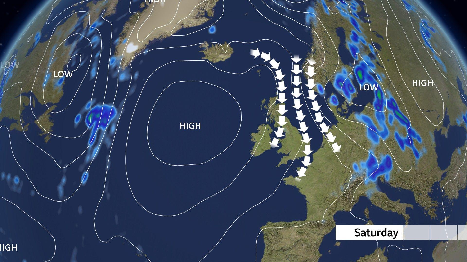
Fresher northerly winds will cause readings to fall by several degrees in some locations, with a significant cooldown in store for parts of Scotland, Northern Ireland and northern England.
However, it will continue to be warmer than average in much of the UK, including southern England where the heatwave threshold has now been met or exceeded for 12 consecutive days.
Despite the break from the heat, there is still no sign of significant rain in the forecast. High pressure will remain close to the UK at least into early next week, continuing the unusually dry and sunny month.
With high pressure centred to the west of the UK, a northerly wind will develop this weekend, causing temperatures to dip.
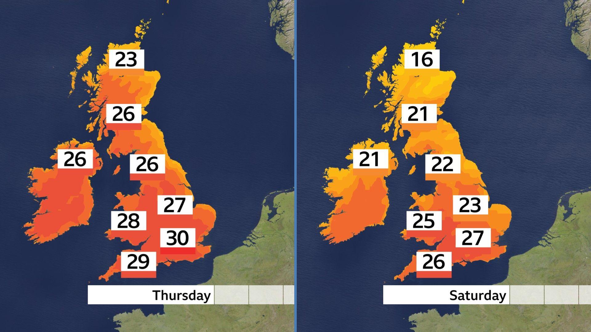
Maximum temperatures in northern Scotland will be up to seven degrees Celsius lower on Saturday than on Thursday, bringing an end to the heatwave.
North-west England will also see temperatures fall by five to six degrees Celsius from Thursday’s maximum, dropping to the low 20s by Saturday.
The Midlands, Wales and southern England will feel some relief, though parts of these regions will continue above the heatwave threshold.
Maximum temperatures here will widely range from 25–27C, though cooler nights will make a welcome return.
Dry weather is set to continue for most over the weekend with no significant rainfall on the cards.
A few locations across south-east England – including Wisley, Surrey and Herstmonceux, East Sussex – have now seen close to 30 days without rain.
Several other locations in the east of England and the West Midlands have gone more than 20 days without.
The dry conditions and increased demand for water has resulted in hosepipe bans for more than eight million households in England.
Wales and Northern Ireland are also far drier than average.
Warmth to bounce back quickly
After the cooler weekend, warmer conditions are forecast to bounce back quickly. Most parts of the UK will remain dry with more sunshine.
Northerly winds are forecast to be lighter, allowing temperatures to creep up again.
Scotland and Northern Ireland will be around 23C, while southern England could return to 30C.
For parts of England and Wales, the heatwave will continue into its third week.
It comes as the Met Office released its state of the climate report for 2025, which said that “climate extremes are becoming the new normal” in the UK.
It revealed that the hottest day of the year in the south of England is now typically 4.5C warmer than it was in 1961-1990.
The country’s climate is “on the move”, according to the report, as northern areas of Britain now see higher temperatures that used to only affect southern England.
-
-
Published5 days ago

-
-
-
Published13 hours ago
-
Disclaimer : This story is auto aggregated by a computer programme and has not been created or edited by DOWNTHENEWS. Publisher: newsrss.bbc.co.uk