High-resolution satellite imagery of three transmission tower sites in North Korea — located in Gujang county, North Pyongan province; Namsan, Kaesong city; and Anak county, South Hwanghae province — reveals facilities operating in carefully calculated configurations tailored to their terrain and antenna structures. Shadow-length analysis, cross-referenced against solar elevation at the time of imaging and local topographic conditions, puts the towers at an estimated 50 to 80 meters in height, a scale consistent with infrastructure capable of broadcasting signals across wide areas. Taken together, the three sites appear to form part of the core infrastructure sustaining North Korea’s broadcast and communications network.
Assessed against their structural characteristics and site positioning, the towers function as key nodes in North Korea’s broadcasting and communications system. The Anak county facility in particular bears structural similarities to antennas commonly used for medium-wave broadcasting. The large lattice towers at Gujang county and Kaesong are likewise configured for wide-area signal transmission and broadcasting. Some facilities may also serve as relay points within military and administrative communications networks. Satellite imagery cannot confirm the specific frequencies in use or operational purposes in detail, making it difficult to state definitively whether activities such as broadcasts directed at South Korea or radio jamming are taking place. Nonetheless, the scale, layout, and antenna types visible in the imagery support an assessment that these transmission facilities serve as important nodes sustaining North Korea’s broadcasting and communications system.
Gujang county, North Pyongan province (coordinates: 40°4’55.46″N, 126°6’38.05″E)

The Voice of Korea transmission facility in Gujang county, North Pyongan province, is one of North Korea’s principal shortwave broadcasting transmission sites. High-resolution satellite imagery reveals a large-scale transmission complex in which multiple antenna masts and transmission towers are systematically arranged across an expanse of flat, open ground. Self-supporting lattice transmission towers installed on square concrete foundations appear designed to transmit signals efficiently using the open terrain, where no surrounding high ground or tall structures impede signal propagation. The scale and layout of the facility are more consistent with a national-level transmission base for operating an international shortwave broadcasting network than with a local broadcasting facility. According to publicly available information, the site is understood to transmit North Korea’s external broadcasting service in multiple languages, including English, Chinese, Russian, and Japanese.
Shadow analysis in the satellite imagery allows an estimate of the facility’s scale. Cross-referencing the imaging date, solar elevation, and the latitude conditions of Gujang county, the main transmission towers are estimated at approximately 60 to 80 meters in height — larger than a typical local communications facility and appropriate for long-distance broadcast and communications signal transmission. The arrangement of multiple antenna systems across a large site reflects the characteristics of a major transmission station operating across multiple frequencies and transmission directions, rather than a single transmitter. Recent reports from shortwave listeners overseas of successfully receiving Voice of Korea broadcasts confirm that the facility continues to function as a key transmission hub supporting North Korea’s external broadcasting and long-distance communications.
Kaesong city transmission tower (coordinates: 37°59’9.75″N, 126°34’20.58″E)
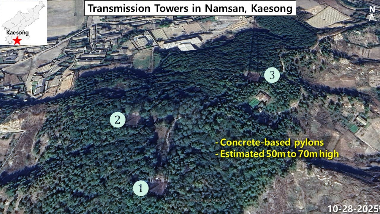
The facility in Namsan neighborhood, Kaesong city, consists of self-supporting lattice transmission towers built along the ridge of a low hill called Namsan, which rises to approximately 110 meters above sea level at the southern edge of the city. Unlike flat-terrain structures, the site exploits natural topographic elevation to maximize the effective range of signal propagation into the surrounding area. The towers use a standard square truss design, self-supporting on square concrete bases without guy wires. Satellite imagery shows that the facility is concentrated at an elevation providing an optimal vantage point over the entire Kaesong urban area.
A striking feature in the satellite imagery is a shadow approximately 100 meters in length. Accounting for the imaging date and time, the facility’s latitude, and local terrain conditions, the actual tower height is estimated at approximately 50 to 70 meters. The site appears to exploit its topographic value to the fullest as a strategic location for military communications and the potential transmission of jamming signals directed at South Korea.
Anak county, South Hwanghae province (coordinates: 38°28’47.16″N, 125°28’37.42″E)
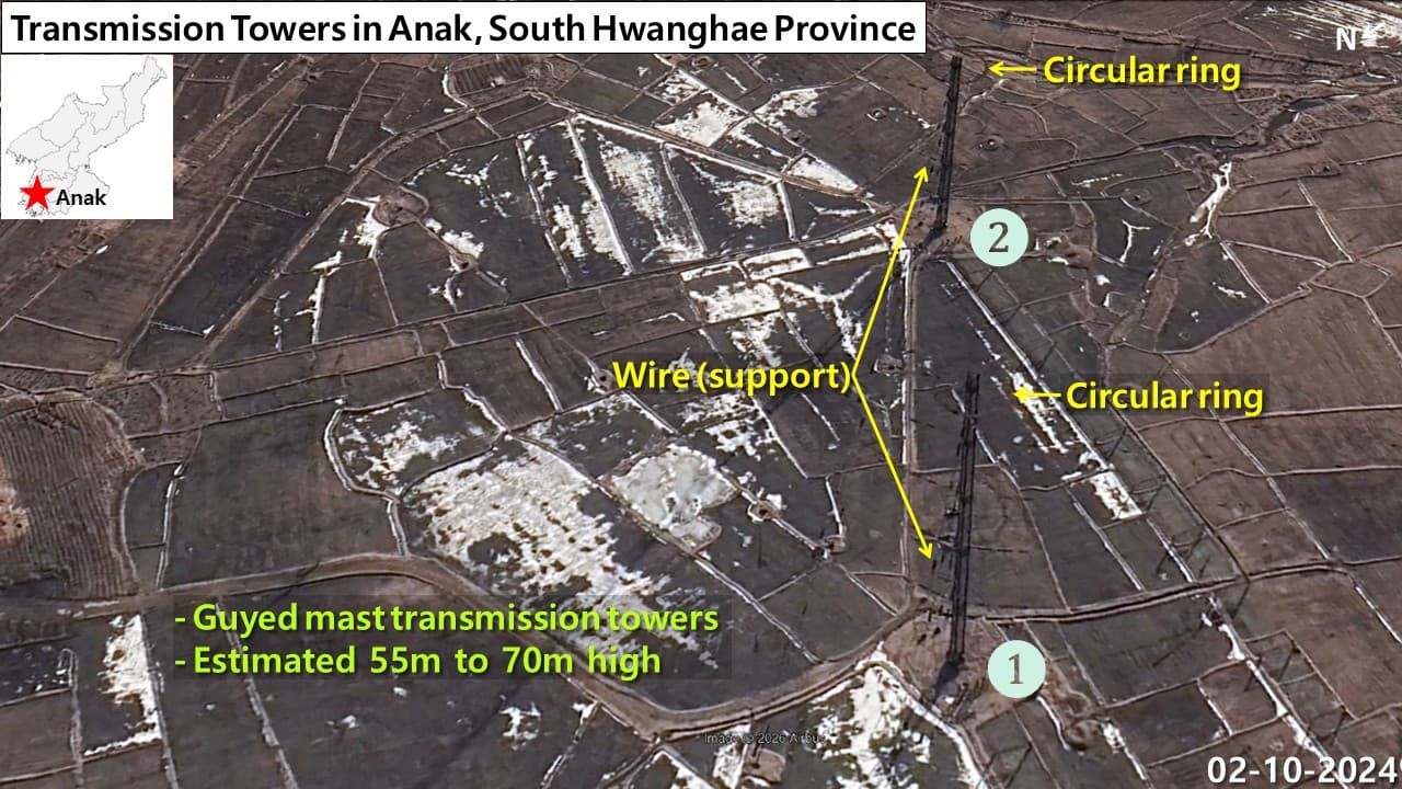
The facility in Anak county, South Hwanghae province, sits in the middle of a wide expanse of flat, open farmland, a classic flat-terrain antenna base that minimizes signal obstruction on all sides. The defining structural features visible in satellite imagery are a circular ring structure mounted at the top of the tower and thin guy wires radiating outward in all directions — characteristics that classify it as a guyed lattice antenna type, in which a slender vertical mast is held upright by wire supports rather than relying on a wide base for stability, in contrast to self-supporting towers. The facility is assessed as high-power medium-frequency broadcasting infrastructure designed to maximize frequency efficiency and transmit signals across the full extent of South Korea or North Korea.
A shadow of approximately 100 meters visible in satellite analysis appears to reflect the significant effect of the winter-season imaging date on shadow length. Accounting for the latitude of the Anak county area and the solar position at the time, the antenna’s actual height is estimated at approximately 55 to 70 meters.
North Korea’s broadcast and communications transmission tower network
North Korea’s transmission towers are core infrastructure for delivering radio broadcasts and various communications signals across wide areas. Given North Korea’s mountainous terrain and the limited communications infrastructure in many parts of the country, the regime operates its broadcasting and communications networks using tall towers and antenna systems. Medium-wave and shortwave broadcasting in particular enable long-distance transmission, making these facilities useful not only for domestic broadcasting aimed at the North Korean public but also for external broadcasts directed at overseas audiences and South Korea. Transmission towers are typically sited on flat ground, hilltops, or ridgelines where signals can travel farthest, and are understood to be operated for broadcasting, communications, or combined purposes depending on their scale and antenna configuration.
Beyond simple broadcasting, these facilities are assessed to play a role in sustaining the national communications network. North Korea operates both wired and wireless networks to maintain communication links between military units, administrative bodies, and regional organizations, and large transmission towers can serve as relay nodes within those networks. Some facilities have been raised as possible sites for broadcasts directed at South Korea or radio jamming operations, though specific operational purposes cannot be confirmed. Taken together, however, satellite imagery and publicly available information indicate that North Korea maintains large transmission facilities at key locations across the country, and that these sites function as critical infrastructure underpinning North Korea’s information and communications system — supporting broadcasting, communications, and emergency command and liaison functions.
Disclaimer : This story is auto aggregated by a computer programme and has not been created or edited by DOWNTHENEWS. Publisher: dailynk.com


